 |
| Snow of 2009/2010 |
|


|
    
|
|
Introduction
The winter of 2009-2010 was a particularly harsh one. The temperatures were consistently below freezing and snow had accumulated to a total close to 60 inches in some locations. Acording to the National Climatic Data Center, February was the snowiest month on record with 51.2 inches. Many building roofs collapsed, power lines were downed, trees were broken and other weight related damage was incurred. See reports from
WTAE-TV and the Beaver County Times for details.
|
| |
| See the Resource from the National Oceanic and Atmospheric Administration for a very good explanation of the factors affecting weather. |
| |
Many emergency managers were seriously concerned about the potential flooding that would result from a rapid melting of the accumulated snow.
|
| Definition: |
Snow Water Equivalent (SWE): Vertical depth of the water that would be obtained by melting a snow layer.
Source: World Meteorological Organization (WMO). |
|
| |
| A rapid snow melt would have the same effect as a rainstorm of the same Snow Water Equivalent. In general SWE factors average around .1 but vary with a number of conditions. Thus 10 inches of snow would be equal to about 1 inch of rain in water content. The 2010 snow accumulation was the same as 6 inches of water on the ground. If a warming spell were accompanied by, say an inch of rain, the result would be similar to a 7 inch rainstorm. |
| |
| What do we do with the snow? |
| |
| Snow on the ground. |
| |
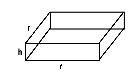 |
| Surface area of snow on the ground: |
| SA = r2 |
| Volume of snow on the ground: |
| V = r2h |
| |
| Snow stacked in a cone. |
| |
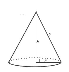 |
| Surface area of a cone: |
| SA = π rs |
| Volume of a cone: |
| V = 1/3 π r2h |
| |
| Snow stacked in a cylinder. |
| |
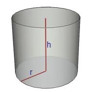 |
| Surface area of a cylinder: |
| SA = π r2 + 2 π r h |
| Volume of a cylinder: |
| V = π r2h |
| |
|
|
|
|
| Copyright © 2011 - 2014 Ken Sochats |